All the Bisses
- Alte Eischlersuon
- Alte Suon/ Meigger suon
- Big bisses trail
- Bisse d'Ayent
- Bisse d'En Bas
- Bisse de Baar
- bisse de Badneri
- Bisse de Beitra
- Bisse de Bitailla
- Bisse de Bodmeri - Niwa
- Bisse de Briey
- Bisse de Chervé
- Bisse de Clavau
- Bisse de Corbassière
- Bisse de Grimisuat
- Bisse de la Tsandra
- Bisse de Lens
- Bisse de Lentine
- Bisse de Mengis
- Bisse de Mont d'Orge
- Bisse de Ricard
- Bisse de Riederi
- Bisse de Salins
- Bisse de Saxon
- Bisse de Sillonin
- Bisse de Sion
- Bisse de St Jean
- Bisse de St Martin
- Bisse de Tsa-Crêta
- Bisse de Varone (Varen)
- Bisse de Vercorin
- Bisse de Vex
- Bisse des Miriouges
- Bisse des Ravines
- Bisse des Sarrasins
- Bisse du Heido
- Bisse du Milieu
- Bisse du Poteu
- Bisse du Ro
- Bisse du Torrent Neuf/Savièse
- Bisse du Trient
- Bisse du Tsittoret
- Bisse Neuf ou Bénou
- Bisse Siphon
- Bisse Vieux
- Bisses de Ergisch et Fätschi
- Bisses de Grächen
- Bisses de Laldneri et Wiigartneri
- Bisses de Nessjeri/Oberschta/Stigwasser
- Bisses de Niwärch and Görperi
- Bisses de Stägeru et Lüegjeru
- Bisses de Stigwasser, Wyssa and Oberschta
- Bisses de Trusera and Wuhr
- Bisses du Tsanpé et Déjore
- Bisses of the Val des Dix
- Bisses Ossona and Sevanne
- Chemin des bisses - 3 jours de marche
- Circuit of 3 bisses
- Giesch-Tatz Suön und Ladu Suön
- Grand bisse de St Luc et bisse Roux
- Heuvete/Moosgufer
- Obere et Untere Wasserleitung
- Petit Bisse
- Petit Ruisseau
- Raye des Verbierins and Bisse de Levron
- Val d'Hérens, 3 bisses loop
Upper Valais
- Alte Eischlersuon
- Alte Suon/ Meigger suon
- bisse de Badneri
- Bisse de Beitra
- Bisse de Bodmeri - Niwa
- Bisse de Mengis
- Bisse de Riederi
- Bisse de Varone (Varen)
- Bisse du Heido
- Bisses de Ergisch et Fätschi
- Bisses de Grächen
- Bisses de Laldneri et Wiigartneri
- Bisses de Nessjeri/Oberschta/Stigwasser
- Bisses de Niwärch and Görperi
- Bisses de Stägeru et Lüegjeru
- Bisses de Stigwasser, Wyssa and Oberschta
- Bisses de Trusera and Wuhr
- Giesch-Tatz Suön und Ladu Suön
- Heuvete/Moosgufer
- Obere et Untere Wasserleitung
Central Valais
- Big bisses trail
- Bisse d'Ayent
- Bisse d'En Bas
- Bisse de Baar
- Bisse de Bitailla
- Bisse de Briey
- Bisse de Chervé
- Bisse de Clavau
- Bisse de Grimisuat
- Bisse de la Tsandra
- Bisse de Lens
- Bisse de Lentine
- Bisse de Mont d'Orge
- Bisse de Ricard
- Bisse de Salins
- Bisse de Saxon
- Bisse de Sillonin
- Bisse de Sion
- Bisse de St Jean
- Bisse de St Martin
- Bisse de Tsa-Crêta
- Bisse de Vercorin
- Bisse de Vex
- Bisse des Miriouges
- Bisse des Sarrasins
- Bisse du Milieu
- Bisse du Poteu
- Bisse du Ro
- Bisse du Torrent Neuf/Savièse
- Bisse du Tsittoret
- Bisse Neuf ou Bénou
- Bisse Siphon
- Bisse Vieux
- Bisses du Tsanpé et Déjore
- Bisses of the Val des Dix
- Bisses Ossona and Sevanne
- Chemin des bisses - 3 jours de marche
- Circuit of 3 bisses
- Grand bisse de St Luc et bisse Roux
- Petit Bisse
- Val d'Hérens, 3 bisses loop
Raye des Verbierins and Bisse de Levron
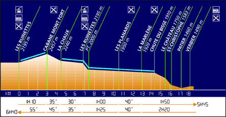
These two bisses run one after the other. Built in the middle of the 16th century. A rarity for bisses of this altitude, they are entirely in water.
Total length : Approximately 18 km as far as Verbier for the return trip.
Altitude : Between 2400 and 1500 metres.
Route time : 5 hours (if you go as far as Verbier on foot).
Location : Verbier - Mont Fort, in the Val de Bagnes.
Difficulty : No particular difficulty, the trail takes in the heights of Verbier to the Levron gulf.
Ordinance Survey map 1 : 50'000 no. 273T Martigny.
Best period : June to September.
This bisse contains water from early June to late October.