- Alte Eischlersuon
- Alte Suon/ Meigger suon
- Big bisses trail
- Bisse d'Ayent
- Bisse d'En Bas
- Bisse de Baar
- bisse de Badneri
- Bisse de Beitra
- Bisse de Bitailla
- Bisse de Bodmeri - Niwa
- Bisse de Briey
- Bisse de Chervé
- Bisse de Clavau
- Bisse de Corbassière
- Bisse de Grimisuat
- Bisse de la Tsandra
- Bisse de Lens
- Bisse de Lentine
- Bisse de Mengis
- Bisse de Mont d'Orge
- Bisse de Ricard
- Bisse de Riederi
- Bisse de Salins
- Bisse de Saxon
- Bisse de Sillonin
- Bisse de Sion
- Bisse de St Jean
- Bisse de St Martin
- Bisse de Tsa-Crêta
- Bisse de Varone (Varen)
- Bisse de Vercorin
- Bisse de Vex
- Bisse des Miriouges
- Bisse des Ravines
- Bisse des Sarrasins
- Bisse du Heido
- Bisse du Milieu
- Bisse du Poteu
- Bisse du Ro
- Bisse du Torrent Neuf/Savièse
- Bisse du Trient
- Bisse du Tsittoret
- Bisse Neuf ou Bénou
- Bisse Siphon
- Bisse Vieux
- Bisses de Ergisch et Fätschi
- Bisses de Grächen
- Bisses de Laldneri et Wiigartneri
- Bisses de Nessjeri/Oberschta/Stigwasser
- Bisses de Niwärch and Görperi
- Bisses de Stägeru et Lüegjeru
- Bisses de Stigwasser, Wyssa and Oberschta
- Bisses de Trusera and Wuhr
- Bisses du Tsanpé et Déjore
- Bisses of the Val des Dix
- Bisses Ossona and Sevanne
- Chemin des bisses - 3 jours de marche
- Circuit of 3 bisses
- Giesch-Tatz Suön und Ladu Suön
- Grand bisse de St Luc et bisse Roux
- Heuvete/Moosgufer
- Obere et Untere Wasserleitung
- Petit Bisse
- Petit Ruisseau
- Raye des Verbierins and Bisse de Levron
- Val d'Hérens, 3 bisses loop
- Alte Eischlersuon
- Alte Suon/ Meigger suon
- bisse de Badneri
- Bisse de Beitra
- Bisse de Bodmeri - Niwa
- Bisse de Mengis
- Bisse de Riederi
- Bisse de Varone (Varen)
- Bisse du Heido
- Bisses de Ergisch et Fätschi
- Bisses de Grächen
- Bisses de Laldneri et Wiigartneri
- Bisses de Nessjeri/Oberschta/Stigwasser
- Bisses de Niwärch and Görperi
- Bisses de Stägeru et Lüegjeru
- Bisses de Stigwasser, Wyssa and Oberschta
- Bisses de Trusera and Wuhr
- Giesch-Tatz Suön und Ladu Suön
- Heuvete/Moosgufer
- Obere et Untere Wasserleitung
- Big bisses trail
- Bisse d'Ayent
- Bisse d'En Bas
- Bisse de Baar
- Bisse de Bitailla
- Bisse de Briey
- Bisse de Chervé
- Bisse de Clavau
- Bisse de Grimisuat
- Bisse de la Tsandra
- Bisse de Lens
- Bisse de Lentine
- Bisse de Mont d'Orge
- Bisse de Ricard
- Bisse de Salins
- Bisse de Saxon
- Bisse de Sillonin
- Bisse de Sion
- Bisse de St Jean
- Bisse de St Martin
- Bisse de Tsa-Crêta
- Bisse de Vercorin
- Bisse de Vex
- Bisse des Miriouges
- Bisse des Sarrasins
- Bisse du Milieu
- Bisse du Poteu
- Bisse du Ro
- Bisse du Torrent Neuf/Savièse
- Bisse du Tsittoret
- Bisse Neuf ou Bénou
- Bisse Siphon
- Bisse Vieux
- Bisses du Tsanpé et Déjore
- Bisses of the Val des Dix
- Bisses Ossona and Sevanne
- Chemin des bisses - 3 jours de marche
- Circuit of 3 bisses
- Grand bisse de St Luc et bisse Roux
- Petit Bisse
- Val d'Hérens, 3 bisses loop
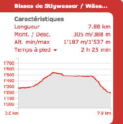
Bisses de Stigwasser, Wyssa and Oberschta
The Stigwasser dates from the beginning of the sixteenth century, the Bisse de Wyssa dates from the fifteenth century.
Total length : Approximately 10 km.
Altitude : Between 1240 and 1550 metres.
Route time : Between 3 and 4 hours.
Location : These two bisses are located above Naters in the region of Mund to the right of the Rhône.
Difficulty : Bisses spectacular. For people who suffer from vertigo, we can avoid the return by the vertiginous part of the bisse Wyssa by borrowing the tunnel of the bisse of Stollen (Wässerwasser Stollen). Bisses very little frequented. To be done in loop beginning with the Stigwasser. Oberschta can also be done as a loop with Stigwasser or Wyssa starting at Birgish.
Ordinance Survey map 1 : 50’000 : no. 274 T Viège (Visp).
Best period : May to early October.