All the Bisses
- Alte Eischlersuon
- Alte Suon/ Meigger suon
- Big bisses trail
- Bisse d'Ayent
- Bisse d'En Bas
- Bisse de Baar
- bisse de Badneri
- Bisse de Beitra
- Bisse de Bitailla
- Bisse de Bodmeri - Niwa
- Bisse de Briey
- Bisse de Chervé
- Bisse de Clavau
- Bisse de Corbassière
- Bisse de Grimisuat
- Bisse de la Tsandra
- Bisse de Lens
- Bisse de Lentine
- Bisse de Mengis
- Bisse de Mont d'Orge
- Bisse de Ricard
- Bisse de Riederi
- Bisse de Salins
- Bisse de Saxon
- Bisse de Sillonin
- Bisse de Sion
- Bisse de St Jean
- Bisse de St Martin
- Bisse de Tsa-Crêta
- Bisse de Varone (Varen)
- Bisse de Vercorin
- Bisse de Vex
- Bisse des Miriouges
- Bisse des Ravines
- Bisse des Sarrasins
- Bisse du Heido
- Bisse du Milieu
- Bisse du Poteu
- Bisse du Ro
- Bisse du Torrent Neuf/Savièse
- Bisse du Trient
- Bisse du Tsittoret
- Bisse Neuf ou Bénou
- Bisse Siphon
- Bisse Vieux
- Bisses de Ergisch et Fätschi
- Bisses de Grächen
- Bisses de Laldneri et Wiigartneri
- Bisses de Nessjeri/Oberschta/Stigwasser
- Bisses de Niwärch and Görperi
- Bisses de Stägeru et Lüegjeru
- Bisses de Stigwasser, Wyssa and Oberschta
- Bisses de Trusera and Wuhr
- Bisses du Tsanpé et Déjore
- Bisses of the Val des Dix
- Bisses Ossona and Sevanne
- Chemin des bisses - 3 jours de marche
- Circuit of 3 bisses
- Giesch-Tatz Suön und Ladu Suön
- Grand bisse de St Luc et bisse Roux
- Heuvete/Moosgufer
- Obere et Untere Wasserleitung
- Petit Bisse
- Petit Ruisseau
- Raye des Verbierins and Bisse de Levron
- Val d'Hérens, 3 bisses loop
Upper Valais
- Alte Eischlersuon
- Alte Suon/ Meigger suon
- bisse de Badneri
- Bisse de Beitra
- Bisse de Bodmeri - Niwa
- Bisse de Mengis
- Bisse de Riederi
- Bisse de Varone (Varen)
- Bisse du Heido
- Bisses de Ergisch et Fätschi
- Bisses de Grächen
- Bisses de Laldneri et Wiigartneri
- Bisses de Nessjeri/Oberschta/Stigwasser
- Bisses de Niwärch and Görperi
- Bisses de Stägeru et Lüegjeru
- Bisses de Stigwasser, Wyssa and Oberschta
- Bisses de Trusera and Wuhr
- Giesch-Tatz Suön und Ladu Suön
- Heuvete/Moosgufer
- Obere et Untere Wasserleitung
Central Valais
- Big bisses trail
- Bisse d'Ayent
- Bisse d'En Bas
- Bisse de Baar
- Bisse de Bitailla
- Bisse de Briey
- Bisse de Chervé
- Bisse de Clavau
- Bisse de Grimisuat
- Bisse de la Tsandra
- Bisse de Lens
- Bisse de Lentine
- Bisse de Mont d'Orge
- Bisse de Ricard
- Bisse de Salins
- Bisse de Saxon
- Bisse de Sillonin
- Bisse de Sion
- Bisse de St Jean
- Bisse de St Martin
- Bisse de Tsa-Crêta
- Bisse de Vercorin
- Bisse de Vex
- Bisse des Miriouges
- Bisse des Sarrasins
- Bisse du Milieu
- Bisse du Poteu
- Bisse du Ro
- Bisse du Torrent Neuf/Savièse
- Bisse du Tsittoret
- Bisse Neuf ou Bénou
- Bisse Siphon
- Bisse Vieux
- Bisses du Tsanpé et Déjore
- Bisses of the Val des Dix
- Bisses Ossona and Sevanne
- Chemin des bisses - 3 jours de marche
- Circuit of 3 bisses
- Grand bisse de St Luc et bisse Roux
- Petit Bisse
- Val d'Hérens, 3 bisses loop
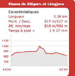
Bisses de Stägeru et Lüegjeru
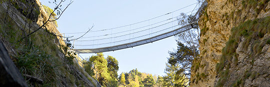
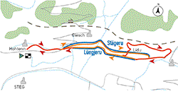
These two bisses are walked in a loop. The Stägeru dates from the mid-sixteenth century. The Lüegjeru was once called the Gutt-Sue. Its water source has been abandoned and it is now fed by the Stägeru.
Total length : Approximately 6 km.
Altitude : Between 850 and 950 metres.
Route time : 2 hours.
Location : To the right of the Rhône, above Niedergesteln and Gampel.
Difficulty : At the point at which the Stägeru takes water there is a vertiginous stretch that can be avoided. Otherwise, there are a few vertical drops of three or four metres but they are equipped with a hand-rail.
Ordinance Survey map 1 : 50'000 no. 274 T Viège (Visp).
Best period : May to November.