- Alte Eischlersuon
- Alte Suon/ Meigger suon
- Big bisses trail
- Bisse d'Ayent
- Bisse d'En Bas
- Bisse de Baar
- bisse de Badneri
- Bisse de Beitra
- Bisse de Bitailla
- Bisse de Bodmeri - Niwa
- Bisse de Briey
- Bisse de Chervé
- Bisse de Clavau
- Bisse de Corbassière
- Bisse de Grimisuat
- Bisse de la Tsandra
- Bisse de Lens
- Bisse de Lentine
- Bisse de Mengis
- Bisse de Mont d'Orge
- Bisse de Ricard
- Bisse de Riederi
- Bisse de Salins
- Bisse de Saxon
- Bisse de Sillonin
- Bisse de Sion
- Bisse de St Jean
- Bisse de St Martin
- Bisse de Tsa-Crêta
- Bisse de Varone (Varen)
- Bisse de Vercorin
- Bisse de Vex
- Bisse des Miriouges
- Bisse des Ravines
- Bisse des Sarrasins
- Bisse du Heido
- Bisse du Milieu
- Bisse du Poteu
- Bisse du Ro
- Bisse du Torrent Neuf/Savièse
- Bisse du Trient
- Bisse du Tsittoret
- Bisse Neuf ou Bénou
- Bisse Siphon
- Bisse Vieux
- Bisses de Ergisch et Fätschi
- Bisses de Grächen
- Bisses de Laldneri et Wiigartneri
- Bisses de Nessjeri/Oberschta/Stigwasser
- Bisses de Niwärch and Görperi
- Bisses de Stägeru et Lüegjeru
- Bisses de Stigwasser, Wyssa and Oberschta
- Bisses de Trusera and Wuhr
- Bisses du Tsanpé et Déjore
- Bisses of the Val des Dix
- Bisses Ossona and Sevanne
- Chemin des bisses - 3 jours de marche
- Circuit of 3 bisses
- Giesch-Tatz Suön und Ladu Suön
- Grand bisse de St Luc et bisse Roux
- Heuvete/Moosgufer
- Obere et Untere Wasserleitung
- Petit Bisse
- Petit Ruisseau
- Raye des Verbierins and Bisse de Levron
- Val d'Hérens, 3 bisses loop
- Alte Eischlersuon
- Alte Suon/ Meigger suon
- bisse de Badneri
- Bisse de Beitra
- Bisse de Bodmeri - Niwa
- Bisse de Mengis
- Bisse de Riederi
- Bisse de Varone (Varen)
- Bisse du Heido
- Bisses de Ergisch et Fätschi
- Bisses de Grächen
- Bisses de Laldneri et Wiigartneri
- Bisses de Nessjeri/Oberschta/Stigwasser
- Bisses de Niwärch and Görperi
- Bisses de Stägeru et Lüegjeru
- Bisses de Stigwasser, Wyssa and Oberschta
- Bisses de Trusera and Wuhr
- Giesch-Tatz Suön und Ladu Suön
- Heuvete/Moosgufer
- Obere et Untere Wasserleitung
- Big bisses trail
- Bisse d'Ayent
- Bisse d'En Bas
- Bisse de Baar
- Bisse de Bitailla
- Bisse de Briey
- Bisse de Chervé
- Bisse de Clavau
- Bisse de Grimisuat
- Bisse de la Tsandra
- Bisse de Lens
- Bisse de Lentine
- Bisse de Mont d'Orge
- Bisse de Ricard
- Bisse de Salins
- Bisse de Saxon
- Bisse de Sillonin
- Bisse de Sion
- Bisse de St Jean
- Bisse de St Martin
- Bisse de Tsa-Crêta
- Bisse de Vercorin
- Bisse de Vex
- Bisse des Miriouges
- Bisse des Sarrasins
- Bisse du Milieu
- Bisse du Poteu
- Bisse du Ro
- Bisse du Torrent Neuf/Savièse
- Bisse du Tsittoret
- Bisse Neuf ou Bénou
- Bisse Siphon
- Bisse Vieux
- Bisses du Tsanpé et Déjore
- Bisses of the Val des Dix
- Bisses Ossona and Sevanne
- Chemin des bisses - 3 jours de marche
- Circuit of 3 bisses
- Grand bisse de St Luc et bisse Roux
- Petit Bisse
- Val d'Hérens, 3 bisses loop
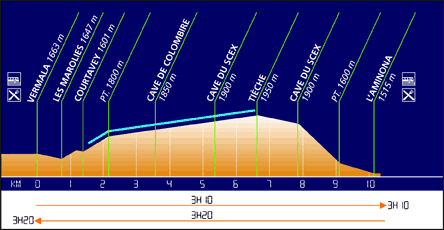
Bisse du Tsittoret
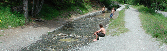
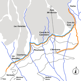
Built in the fifteenth century, this bisse has the particularity of taking its source from the Tièche which becomes the Raspille and which separates the canton of Valais into its two linguistic regions.
Total length : 8 km without the return trip.
Altitude : Between 1950 and 1500 metres.
Route time : Approximately 4.5 hours including the return trip.
Location : Crans-Montana, les Violettes and Aminona to the right of the Rhône. A panoramic trail with spectacular views over the Valaisan Alps and the 4000 metre peaks of the Val d’Anniviers (Weisshorn, Zinalrothorn et Obergabelhorn). From the point at which the bisse takes water one can even spot the Cervin (Matterhorn) and the Dent d’Hérens as well as the Arête des 4 Ânes and the Dent Blanche.
Difficulty : There are no particular difficulties.
Ordinance Survey map 1 : 50'000 no. 273 T Montana.
Best period : May to October.
This bisse contains water from late May to late September.